Difference between revisions of "Riverbed infiltration galleries"
| (24 intermediate revisions by 2 users not shown) | |||
| Line 1: | Line 1: | ||
| − | [[Image:OmoRiver.jpg|thumb|right| | + | {{Language-box|english_link= Riverbed infiltration galleries | french_link= Coming soon | spanish_link= Coming soon | hindi_link= Coming soon | malayalam_link= Coming soon | tamil_link= Coming soon | swahili_link=coming soon | korean_link= Coming soon | chinese_link=河床滲渠式集水廊道 | indonesian_link= Coming soon | japanese_link= Coming soon }} |
| + | |||
| + | [[Image:riverbed infiltration galleries icon.png|right|80px]] | ||
| + | [[Image:OmoRiver.jpg|thumb|right|200px|The Omo River in Ethiopia, Africa. <br>Photo: [http://www.flickr.com/photos/neslab/6826784275/ Davide Comelli.]]] | ||
Channels take water from a riverbed to a collector well in the riverbank. They are often screens (slotted or perforated pipes) that are inserted horizontally into a riverbed, but also infiltration galleries can be made from channels with graded gravel as long as sediments are not washed into the collector well. Where screens are used, the screen diameter tends to be larger than that used normally for jetted/driven wells. | Channels take water from a riverbed to a collector well in the riverbank. They are often screens (slotted or perforated pipes) that are inserted horizontally into a riverbed, but also infiltration galleries can be made from channels with graded gravel as long as sediments are not washed into the collector well. Where screens are used, the screen diameter tends to be larger than that used normally for jetted/driven wells. | ||
Riverbeds having catchments of flat farmland usually contain fine textured sand, that can only yield a maximum of 100 litres of water from 1 m3. of sand, i.e. an extraction rate of 10%. Stony riverbeds containing boulders and fractured rocks have the lowest potential for water extraction due to seepage caused by the boulders and fractured rocks. This seepage is, however, beneficial for replenishment of boreholes situated on riverbanks. | Riverbeds having catchments of flat farmland usually contain fine textured sand, that can only yield a maximum of 100 litres of water from 1 m3. of sand, i.e. an extraction rate of 10%. Stony riverbeds containing boulders and fractured rocks have the lowest potential for water extraction due to seepage caused by the boulders and fractured rocks. This seepage is, however, beneficial for replenishment of boreholes situated on riverbanks. | ||
| − | ==Suitable conditions== | + | ===Suitable conditions=== |
* Infiltration galleries are often installed in shallow or fine sediment beds where there is poor permeability or lack of sand depth – in this case, the length proves to be advantageous. | * Infiltration galleries are often installed in shallow or fine sediment beds where there is poor permeability or lack of sand depth – in this case, the length proves to be advantageous. | ||
* They can also be sited in areas where riverbanks are too high to allow manual or motorized suction pumps to operate. | * They can also be sited in areas where riverbanks are too high to allow manual or motorized suction pumps to operate. | ||
| Line 11: | Line 14: | ||
| − | { | + | {| border="1" cellpadding="5" cellspacing="0" align="center" |
| − | - Allows a method of water extraction where sand depth is shallow or where sediments are fine and have low permeability <br> | + | |- |
| + | ! width="50%" style="background:#efefef;" | Advantages | ||
| + | ! style="background:#f0f8ff;" | Disadvantages | ||
| + | |- | ||
| + | | valign="top" | - Allows a method of water extraction where sand depth is shallow or where sediments are fine and have low permeability <br> | ||
- Cheap where it can be done without shuttering <br> | - Cheap where it can be done without shuttering <br> | ||
| − | | | + | | valign="top" | - Difficult to make deep enough to ensure water at all times. Laying deeper galleries involves digging deeper and preventing sand trenches from collapsing by using shuttering – this becomes a more involved and expensive process <br> |
| − | - Difficult to make deep enough to ensure water at all times. Laying deeper galleries involves digging deeper and preventing sand trenches from collapsing by using shuttering – this becomes a more involved and expensive process <br> | ||
- Significant amount of work involved <br> | - Significant amount of work involved <br> | ||
- Difficult to construct where riverbanks are not alluvial (where rock breaking techniques required) <br> | - Difficult to construct where riverbanks are not alluvial (where rock breaking techniques required) <br> | ||
- Can clog up over time | - Can clog up over time | ||
| − | + | |} | |
| − | ==Resilience to changes in the environment== | + | |
| + | ===Resilience to changes in the environment=== | ||
====Drought==== | ====Drought==== | ||
| − | '''Effects of drought''': Can dry up. | + | '''Effects of drought''': Can dry up. <br> |
| + | '''Underlying causes of effects''': Less recharge of aquifer due to less rainfall; Increasing population & water demand; Size of aquifers – e.g. limited sand volume; Wells not sunk deep enough into water table; Incorrect siting; Graded gravel around pipe not correctly done.<br> | ||
| + | '''To increase resiliency of WASH system''': Increase volume through construction of groundwater dam; Sink wells/pipes deeper; De-water wells during caissoning within the water table; Construct during the latter half of the dry season; Site in riverbeds that are dry for part of the year, where water remains in the riverbed throughout the dry season; Increase flow by use of porous concrete & perforated pointed steel pipes driven horizontally into the aquifer (riverbed wells) and graded gravel (infiltration galleries & jetted wells); Site in a degrading river section where there is no deposition (infiltration galleries); Put graded gravel around pipes to minimize clogging and increase flow. | ||
| − | |||
| − | + | More information on managing drought: [[Resilient WASH systems in drought-prone areas]]. | |
| − | ==Construction, operations and maintenance== | + | ===Construction, operations and maintenance=== |
'''General advice on cement''': A common cause of cracks in structures and linings (e.g. in tanks, dams, waterways, wells) is errors in mixing and applying the cement. First of all, it is important that only pure ingredients are used: clean water, clean sand, clean rocks. The materials have to be mixed very thoroughly. Secondly, the amount of water during mixing needs to minimal: the concrete or cement needs to be just workable, on the dry side even, and not fluid. Thirdly, it is essential that during curing the cement or concrete is kept moist at all times, for at least a week. Structures should be covered with plastic, large leaves or other materials during the curing period, and kept wet regularly. | '''General advice on cement''': A common cause of cracks in structures and linings (e.g. in tanks, dams, waterways, wells) is errors in mixing and applying the cement. First of all, it is important that only pure ingredients are used: clean water, clean sand, clean rocks. The materials have to be mixed very thoroughly. Secondly, the amount of water during mixing needs to minimal: the concrete or cement needs to be just workable, on the dry side even, and not fluid. Thirdly, it is essential that during curing the cement or concrete is kept moist at all times, for at least a week. Structures should be covered with plastic, large leaves or other materials during the curing period, and kept wet regularly. | ||
| − | [[Image:InfiltrationGalleryDiagram.jpg|thumb|right| | + | [[Image:InfiltrationGalleryDiagram.jpg|thumb|right|200px|Infiltration gallery. <br> Drawing: © Ken Chatterton. In: Hussey, S.W. (2007) Water from sand rivers: guidelines for abstraction. WEDC, Loughborough University, UK.]] |
| − | [[Image:InfiltrationGalleryBuild.jpg|thumb|right| | + | [[Image:InfiltrationGalleryBuild.jpg|thumb|right|200px|Building an infiltration gallery. Infiltration Area: 1080 ft2 (100.3 m2). Cost - $9.33/foot2. Overseas supplier (AUS).]] |
====How deep is the water table?==== | ====How deep is the water table?==== | ||
| Line 40: | Line 48: | ||
Since the trees below must have their tap root in the water table, the depth of a water-table can be found by knowing the depth of the tree’s tap root. A rule of thumb states that the tap root of a tree has a depth equal to about 3⁄4 of the height of the tree. The height of a tree can be found by measuring the length of the shadow the tree is casting on the ground and comparing it with the length of the shadow of a stick 100 centimeters long. The two measurements should be taken in the sunshine of early morning or late afternoon when the shadows are longest. For example: If the stick’ shadow is 80 cm long, the ratio is: 80/100 = 0.8. If the tree’s shadow is 12 m long, then the tree is: 12 m x 5 / 4 = 15 m high and the tap root and water level is at: 15 m x 3⁄4 = 11.25 m depth. | Since the trees below must have their tap root in the water table, the depth of a water-table can be found by knowing the depth of the tree’s tap root. A rule of thumb states that the tap root of a tree has a depth equal to about 3⁄4 of the height of the tree. The height of a tree can be found by measuring the length of the shadow the tree is casting on the ground and comparing it with the length of the shadow of a stick 100 centimeters long. The two measurements should be taken in the sunshine of early morning or late afternoon when the shadows are longest. For example: If the stick’ shadow is 80 cm long, the ratio is: 80/100 = 0.8. If the tree’s shadow is 12 m long, then the tree is: 12 m x 5 / 4 = 15 m high and the tap root and water level is at: 15 m x 3⁄4 = 11.25 m depth. | ||
| − | [[File:WaterTableDepthChart.jpg]] | + | [[File:WaterTableDepthChart.jpg|thumb|none|500px|Vegetation that tells you how deep the water is beneath it. Click on chart to zoom in.]] |
====Other considerations==== | ====Other considerations==== | ||
| Line 54: | Line 62: | ||
* A bucket and rope can be used but risk of contamination increases. In such a case, household water treatment should be advocated. | * A bucket and rope can be used but risk of contamination increases. In such a case, household water treatment should be advocated. | ||
| − | ==Costs== | + | ===Costs=== |
Below is an example of the costs of labour, materials, and transportation to install a river infiltration system. Currency is in the Kenyan shilling. 100 Ksh = 1.20 USD.<br> | Below is an example of the costs of labour, materials, and transportation to install a river infiltration system. Currency is in the Kenyan shilling. 100 Ksh = 1.20 USD.<br> | ||
| − | Find out more about installing a riverbed infiltration system, Chapter 4 of [http://www. | + | Find out more about installing a riverbed infiltration system, Chapter 4 of [http://www.waterforaridland.com/docs/dryriverbeds/Water%20from%20dry%20riverbeds.zip Water from Dry Riverbeds]. Waterforaridland.com. |
| − | + | [[File:InfiltrationPipeCosts.jpg|500px]] | |
| + | |||
| + | ===Manuals, videos, and links=== | ||
| + | * [http://www.watersanitationhygiene.org/References/EH_KEY_REFERENCES/WATER/Surface%20Water/Designing%20Intakes%20for%20Streams%20and%20Rivers%20%28USAID%29.pdf Designing Intakes for Rivers and Streams]. Water for the World. - Lots of design diagrams and instructions on how to build a river intake system. | ||
| + | |||
| + | * [http://www.waterforaridland.com/Books/Book3%20water%20from%20dry%20riverbedspdf.pdf Water from Dry Riverbeds]. Waterforaridland.com. | ||
| − | + | * [http://www.nwri-usa.org/pdfs/BowerSession8Presentationfinal.pdf Infiltration Gallery Testing for Integration into Dual Purpose Irrigation Systems: Managed Aquifer Recharge in Walla Walla Basin]. Robert Bower, 2011. | |
| − | == | + | ===Acknowledgements=== |
| − | + | * CARE Nederland, Desk Study: [[Resilient WASH systems in drought-prone areas]]. October 2010. | |
| − | * [ | ||
| − | |||
| − | + | * Nissen-Petersen, Erik, [http://www.waterforaridland.com/Books/Book3%20water%20from%20dry%20riverbedspdf.pdf Water from Dry Riverbeds: How dry and sandy riverbeds can be turned into water sources by hand-dug wells, subsurface dams, weirs and sand dams] or ([http://docs.watsan.net/Scanned_PDF_Files/Class_Code_2_Water/212.0-06WA-18985.pdf alternative link]) Danish International Development Assistance (Danida) 2006. Waterforaridland.com. | |
| − | |||
| − | * Nissen-Petersen, Erik, [http://www. | ||
Latest revision as of 23:26, 5 September 2016
| |
|
|
|
|
|
|
|
|
|
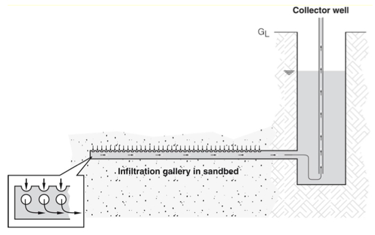
Channels take water from a riverbed to a collector well in the riverbank. They are often screens (slotted or perforated pipes) that are inserted horizontally into a riverbed, but also infiltration galleries can be made from channels with graded gravel as long as sediments are not washed into the collector well. Where screens are used, the screen diameter tends to be larger than that used normally for jetted/driven wells.
Riverbeds having catchments of flat farmland usually contain fine textured sand, that can only yield a maximum of 100 litres of water from 1 m3. of sand, i.e. an extraction rate of 10%. Stony riverbeds containing boulders and fractured rocks have the lowest potential for water extraction due to seepage caused by the boulders and fractured rocks. This seepage is, however, beneficial for replenishment of boreholes situated on riverbanks.
Contents
Suitable conditions
- Infiltration galleries are often installed in shallow or fine sediment beds where there is poor permeability or lack of sand depth – in this case, the length proves to be advantageous.
- They can also be sited in areas where riverbanks are too high to allow manual or motorized suction pumps to operate.
- There should be water remaining in the riverbed throughout the dry season.
- Make it in a degrading river section where there is no deposition, so there are coarser grains and no silt deposits blocking flow.
| Advantages | Disadvantages |
|---|---|
| - Allows a method of water extraction where sand depth is shallow or where sediments are fine and have low permeability - Cheap where it can be done without shuttering |
- Difficult to make deep enough to ensure water at all times. Laying deeper galleries involves digging deeper and preventing sand trenches from collapsing by using shuttering – this becomes a more involved and expensive process - Significant amount of work involved |
Resilience to changes in the environment
Drought
Effects of drought: Can dry up.
Underlying causes of effects: Less recharge of aquifer due to less rainfall; Increasing population & water demand; Size of aquifers – e.g. limited sand volume; Wells not sunk deep enough into water table; Incorrect siting; Graded gravel around pipe not correctly done.
To increase resiliency of WASH system: Increase volume through construction of groundwater dam; Sink wells/pipes deeper; De-water wells during caissoning within the water table; Construct during the latter half of the dry season; Site in riverbeds that are dry for part of the year, where water remains in the riverbed throughout the dry season; Increase flow by use of porous concrete & perforated pointed steel pipes driven horizontally into the aquifer (riverbed wells) and graded gravel (infiltration galleries & jetted wells); Site in a degrading river section where there is no deposition (infiltration galleries); Put graded gravel around pipes to minimize clogging and increase flow.
More information on managing drought: Resilient WASH systems in drought-prone areas.
Construction, operations and maintenance
General advice on cement: A common cause of cracks in structures and linings (e.g. in tanks, dams, waterways, wells) is errors in mixing and applying the cement. First of all, it is important that only pure ingredients are used: clean water, clean sand, clean rocks. The materials have to be mixed very thoroughly. Secondly, the amount of water during mixing needs to minimal: the concrete or cement needs to be just workable, on the dry side even, and not fluid. Thirdly, it is essential that during curing the cement or concrete is kept moist at all times, for at least a week. Structures should be covered with plastic, large leaves or other materials during the curing period, and kept wet regularly.
How deep is the water table?
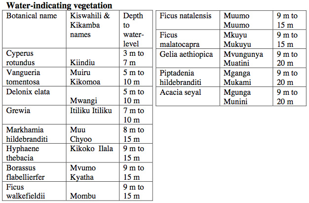
Some rural people and most well-diggers know that water can only be found at certain places in riverbeds. They can also give a rough estimate on how deep they have to dig before reaching the water-table.Their knowledge is based on the fact that certain species of trees and vegetation must have roots reaching down and into the water-table in order to survive droughts. This traditional information (based on Kenyan plants) is compiled in the table below as an example. Make sure to find the unique regional plants specific to your site area.
Since the trees below must have their tap root in the water table, the depth of a water-table can be found by knowing the depth of the tree’s tap root. A rule of thumb states that the tap root of a tree has a depth equal to about 3⁄4 of the height of the tree. The height of a tree can be found by measuring the length of the shadow the tree is casting on the ground and comparing it with the length of the shadow of a stick 100 centimeters long. The two measurements should be taken in the sunshine of early morning or late afternoon when the shadows are longest. For example: If the stick’ shadow is 80 cm long, the ratio is: 80/100 = 0.8. If the tree’s shadow is 12 m long, then the tree is: 12 m x 5 / 4 = 15 m high and the tap root and water level is at: 15 m x 3⁄4 = 11.25 m depth.
Other considerations
- The length of screen required will be greater for an infiltration gallery than for a jetted or driven well – in an infiltration gallery, water flows to the collector well under hydraulic head rather than being pumped out with a suction pump. Diameter of screen used is typically 75 – 300 mm PVC and varies from a few metres up to several hundred metres in length. Layouts vary according to the river widths. Yields are typically 15 litres/min/metre, but depends on depth from river to sump.
- Ensure that galleries are dug deep enough to allow enough flow during the dry season. In practical terms, this means aiming for at least 1 metre depth within the saturated zone. If more than one pipe are installed, distance between pipes should not be less than 3 metres.
- The top of the gallery should be ideally 1.5 metres minimum from the riverbed surface. This is so that:
- There is at least a minimum of infiltration that occurs from surface water during the wet season when the river is flooded.
- There is less chance that the well shaft and pipework will be washed away in a flood event. Sand becomes mobile to a certain depth which differs for different rivers but has been recorded to be normally between 0.66 and 2 metres in seasonal riverbeds.
- Graded gravel needs to be placed under and over the pipe to minimize clogging with sediments.
Water extraction
- Water from infiltration galleries runs to collector wells from where it can be abstracted with Handpumps or Small and efficient motor pumps. The collector well is a hand-dug well which acts as a waterproof chamber – it is dug deeper than the infiltration gallery to allow water to enter by gravity and to allow enough storage volume.
- A bucket and rope can be used but risk of contamination increases. In such a case, household water treatment should be advocated.
Costs
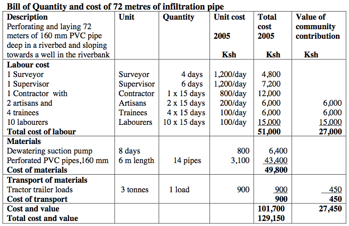
Below is an example of the costs of labour, materials, and transportation to install a river infiltration system. Currency is in the Kenyan shilling. 100 Ksh = 1.20 USD.
Find out more about installing a riverbed infiltration system, Chapter 4 of Water from Dry Riverbeds. Waterforaridland.com.
Manuals, videos, and links
- Designing Intakes for Rivers and Streams. Water for the World. - Lots of design diagrams and instructions on how to build a river intake system.
- Water from Dry Riverbeds. Waterforaridland.com.
- Infiltration Gallery Testing for Integration into Dual Purpose Irrigation Systems: Managed Aquifer Recharge in Walla Walla Basin. Robert Bower, 2011.
Acknowledgements
- CARE Nederland, Desk Study: Resilient WASH systems in drought-prone areas. October 2010.
- Nissen-Petersen, Erik, Water from Dry Riverbeds: How dry and sandy riverbeds can be turned into water sources by hand-dug wells, subsurface dams, weirs and sand dams or (alternative link) Danish International Development Assistance (Danida) 2006. Waterforaridland.com.
