4. Analysis of legal tools
<< The Integrated Coastal Zone Management (ICZM) for the Northern Coast of Central Java
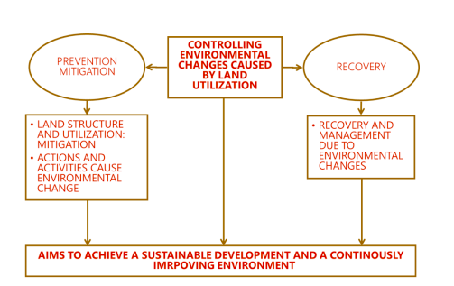
The planning system in Indonesia is generally set up with an approach to control and direct development so that changes that occur do not cause adverse impacts on the environment and sustainable development is achieved. Therefore, spatial planning tools in Indonesia include control and permitting tools.
The spatial tools include:
- Delineation of build up and non build up area
- Zoning Regulation at the RDTR level related to the protection, utilization and control of development in water areas
Other Tools
- Environmental Impact Assessment with adaptive Strategic Environmental Assessment for specifice coastal zone being applied through location, planning and development, building permit
- Strategic Environmental Assessment or Kajian Lingkungan Hidup Strategis (KLHS) for coastal area based on its strategic issues
- Environmental Risk Assessment to justify specific development activities
- Watershed sustainable management informed by aquipher water balance
- Other Coastal Resources Management Tools
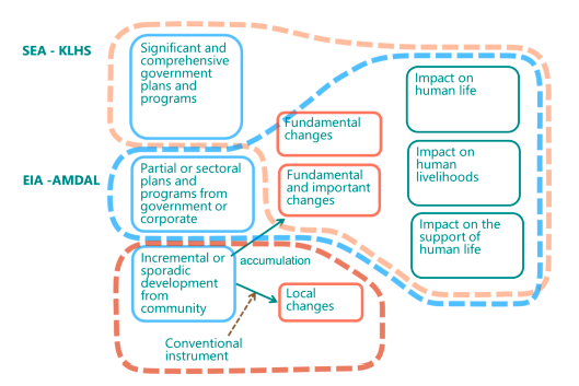
In general, the form of planning control in Indonesia is differentiated based on the level/magnitude of the activity, the scale of its development, and the type of change that may occur. For significant comprehensive and national actions and activities that are expected to have a sizeable socio-environmental impact, the plan will be evaluated through a KLHS study. In addition, partial/sectoral activities managed by the government and corporations with a sizeable social-environment impact will be assessed through the AMDAL process to obtain environmental permits. Meanwhile, incremental/sporadic activities carried out by the community, which are expected to have an impact on the local environment, are controlled through conventional instruments such as the following:
- Regulation, development control and permitting (Spatial plan, Location Permit, Planning Permit, Development Permit)
- Incentive and disincentive economic and fiscal
- Investment (Public and Private) (Priority list, Negative list)
- Mobilization and participation
In terms of Integrated Coastal Zone Management (ICZM), problems with its implementation in Indonesia are as follow (Farhan, Lim, 2010):
- Policy and financial factor: emphasis on agriculture, lack of policy and inconsistency;
- Environmental factor: overfishing and overexploitation of natural resources, erosion, abrasion, pollution, lost and declining biodiversity and mismanagement;
- Socio-economic factor: emphasis on new infrastructure development rather than optimizing the existing infrastructure and regardless of the consequences to the environment, poverty and lack of knowledge;
- Ocean and coastal observation: only few ocean and coastal observation equipment (such as oceanographic buoy, tidal gauge, etc) and lack of maintenance.
Complexity and large area of sea’s and oceans in Indonesia has brought problems in management, safety and security. There are five national issues of ocean and marine management in Indonesia (Farhan, Lim, 2010):
- Conservation and restoration management: marine ecosystem based management and ICZM.
- Operation and management of marine infrastructure: ocean and coastal infrastructure, mitigation and adaption to climate changes
- Ocean and coastal data management: management of scientific data and information, marine information and communication technology.
- Maritime security management: maritime boundary, marine safety and maritime spatial planning.
- Ocean and coastal exploration management: ocean energy exploration and seabed mineral resources exploration.
Future development challenges regarding climate change, natural disasters, and rapid development dynamics require planning tools that can respond to changes that occur more dynamically. Planning tools also need to open up opportunities for community involvement and be in line with existing technological developments.
Integrated Costal Zone Management implementation will have a significant impact on and contribution to coastal and ocean management in Indonesia. It will give better understanding of the coastal and ocean. In order to achieve this, several issues need to be solved (Farhan, Lim, 2010):
- Regulations and laws framework for ICZM must be addressed effectively, this will include the regulations in both central government and local governments.
- The strengthening of Indonesian Global Ocean Observing System (INA-GOOS) is necessary as part of future direction of ICZM. INA-GOOS could be a benefit for Indonesian ICZM in term of monitoring and evaluation of Indonesian coastal and ocean based on scientific information and evidences. INA-GOOS also could be an integration framework between other Indonesian research agencies as well as local governments in order to search for suitable of ICZM implementation in Indonesia as well as International acknowledgement on sustainability development in Indonesia.
- A Decision Support System (DSS) system need to be developed to facilitate and assist decision-makers in evaluating the necessary aspects of ICZM for better management.
INA-GOOS Strategic Plan Document:
Acknowledgements[edit | edit source]
Victor Coenen (Witteveen+Bos), Susan Arts (TwynstraGudde, Jaap de Heer (TwynstraGudde), Mugy Grimwaldy (Bita Bina Semesta) and Henni Hendarti (Deltares), 30-9-2021
Final content report Integrated Coastal Zone Management for the Central Java Province


