Difference between revisions of "Water Portal / Rainwater Harvesting / Groundwater recharge / Bunds"
(→Suitable conditions) |
(→Suitable conditions) |
||
| Line 7: | Line 7: | ||
==Suitable conditions== | ==Suitable conditions== | ||
| − | * Locate bunds in natural runoff areas, preferably in sites already shaped by topography – indicators include seeing where water flows during flood times, and soil / vegetation types. The key is to approach each site individually and to work with natural topographical features – experience in the | + | * Locate bunds in natural runoff areas, preferably in sites already shaped by topography – indicators include seeing where water flows during flood times, and soil / vegetation types. The key is to approach each site individually and to work with natural topographical features – experience in the area will influence the design. |
| − | area will influence the design. | ||
* Avoid the following areas: | * Avoid the following areas: | ||
1. Clay areas – bunds made from soil with high clay content develop leaks through pipes in the bund structure which form due to cracks when it dries. <br> | 1. Clay areas – bunds made from soil with high clay content develop leaks through pipes in the bund structure which form due to cracks when it dries. <br> | ||
Revision as of 00:54, 30 March 2012

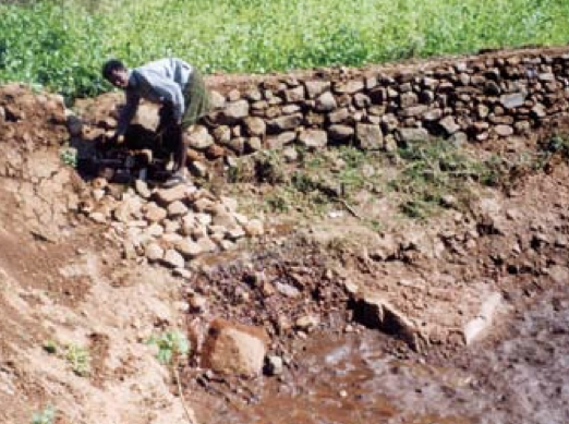
Bunds (also called teras) are small barriers to runoff coming from external catchments (and possibly to a field where crops are to be grown). Bunds slow down water sheet flow on the ground surface and encourage infiltration (groundwater recharge) and soil moisture. This plot of land is "bunded" on three sides, with the fourth side left open to capture runoff from an elevated area. The bunds consist of small stone or earthen walls constructed along the contour of a plot of land. Bunds also trap sediment and prevent erosion or land degradation. A small channel on the inside of the bunds is made to let the water run along. Excess water drains along the tips of the outer arms. These spillways may improve the efficiency and reduce maintenance costs of the teras. The base bund can be 50-300 meters long, while the arms are usually 20-100 meters long.
They can vary in design and include non-enclosed systems (e.g. trapezoidal bunds where water escapes around the edges), and enclosed systems (e.g. bunded fields where water enters via a channel and escapes from a spillway in the bund once the field is flooded). In certain site-specific examples, they are used to create small artificial glaciers which helps release melt water slowly, so as to adjust to short sowing seasons.
Teras show higher crop returns in dryer years and allow farmers to diversify income sources in normal years. In West Africa the technology is widely used in valley bottoms.
Suitable conditions
- Locate bunds in natural runoff areas, preferably in sites already shaped by topography – indicators include seeing where water flows during flood times, and soil / vegetation types. The key is to approach each site individually and to work with natural topographical features – experience in the area will influence the design.
- Avoid the following areas:
1. Clay areas – bunds made from soil with high clay content develop leaks through pipes in the bund structure which form due to cracks when it dries.
2. Proximity to large water courses.
3. Sites needing extensive levelling.
- Soil in vicinity needs to have sufficient infiltration capacity.
- Ideally the slope should not be greater than 1.5% otherwise earthworks get prohibitive.
- For artificial glaciers, altitude needs to be over 4,600 metres.
- Foothill areas with high intensity and short duration rainfall with between 50 and 400 mm rainfall annually.
- Catchments are typically 2 to 3 times the size of cultivated areas in (semi-) arid regions.
