Difference between revisions of "वाटर पोर्टल / वर्षाजल संचयन / सतही जल / सड़क पर बरसे जल का संचयन"
| Line 22: | Line 22: | ||
This technology is categorized under WOCAT (World Overview of Conservation Approaches and Technologies) as a combined structural / vegetative measure. [[Bunds]] | This technology is categorized under WOCAT (World Overview of Conservation Approaches and Technologies) as a combined structural / vegetative measure. [[Bunds]] | ||
| − | इस तकनीक को डब्ल्यूओसीएटी (वर्ल्ड ओवरव्यू ऑफ कंजरवेशन अप्रोच्स ऐंड टेकनॉलॉजीज) के तहत एक संयुक्त | + | इस तकनीक को डब्ल्यूओसीएटी (वर्ल्ड ओवरव्यू ऑफ कंजरवेशन अप्रोच्स ऐंड टेकनॉलॉजीज) के तहत एक संयुक्त ढाँचागत पौधरोपण उपाय ([वाटर पोर्टल/ वर्षाजल संचयन/ भूजल पुनर्भरण/ पुस्ता या खेत-बन्धी]) के रूप में सूचीबद्ध किया गया. गठ्ठों और नहरों को बारहमासी घास से स्थिर किया जाता है. इसका प्राथमिक उद्देश्य मिट्टी में नमी पैदा करना है ताकि बढिय़ा पैदावार हो. इसका प्रभाव जल संरक्षण से पैदा होता है. मृदा संरक्षण की बदौलत जमीन का क्षरण रुकता है. |
तारकोल की सडक़ पर बहते पानी को करीब 300 मीटर लंबी नहर के जरिए लाया गया जो एक पड़ोसी के खेत से कट कर आती है. इसके अलावा भी कुछ पूरक नहर बनाई गईं जो पहाड़ी से बहते पानी को एकत्रित करतीं. अनुमानित भंडारण क्षेत्र करीब 10 हेक्टेयर है। इससे करीब 5 हेक्टेयर क्षेत्र में सिंचाई होती है. प्रमुख नहर पानी को शुरुआती फान्या चिनि (एक ऐसी नहर जो धरती के सहारे ढलान से बहती है) ढांचे की मदद से निकालती है. जब पानी नहर के आखिरी सिरे पर पहुंचती है तब उसे ऐसे ही एक अन्य ढांचे में मिला दिया जाता है जो पानी को एकदम दूसरी दिशा मेंं ले जाता है. दूसरे शब्द मेंं कहें तो पानी जिगजैग शैली में बहता है. कुछ खास स्थानों पर किसान ने पानी को नियंत्रित करने के लिए गेट लगाया है. इनकी मदद से पानी की दिशा तय की जाती है. | तारकोल की सडक़ पर बहते पानी को करीब 300 मीटर लंबी नहर के जरिए लाया गया जो एक पड़ोसी के खेत से कट कर आती है. इसके अलावा भी कुछ पूरक नहर बनाई गईं जो पहाड़ी से बहते पानी को एकत्रित करतीं. अनुमानित भंडारण क्षेत्र करीब 10 हेक्टेयर है। इससे करीब 5 हेक्टेयर क्षेत्र में सिंचाई होती है. प्रमुख नहर पानी को शुरुआती फान्या चिनि (एक ऐसी नहर जो धरती के सहारे ढलान से बहती है) ढांचे की मदद से निकालती है. जब पानी नहर के आखिरी सिरे पर पहुंचती है तब उसे ऐसे ही एक अन्य ढांचे में मिला दिया जाता है जो पानी को एकदम दूसरी दिशा मेंं ले जाता है. दूसरे शब्द मेंं कहें तो पानी जिगजैग शैली में बहता है. कुछ खास स्थानों पर किसान ने पानी को नियंत्रित करने के लिए गेट लगाया है. इनकी मदद से पानी की दिशा तय की जाती है. | ||
Revision as of 04:42, 4 December 2015
| |
|
|
|
|
|
|
|
|
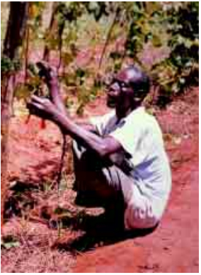
नजदीक की किसी सड़क पर से बहने वाले पानी का संरक्षण करना एक ऐसी तकनीक है जिसकी शुरुआत मविंगी जिले के क्येथानी के मुस्योका मुइंदु ने की थी. वह सन 1993 से लगातार इस प्रणाली को विकसित करने के काम में लगे थे. यह काफी हद तक जमीनी अनुभवोंं और पर्यवेक्षण पर आधारित था. इसके जल और मृदा संरक्षण को कृषि और ग्रामीण विकास मंत्रालय (मोराड) का प्रशिक्षण और मदद भी हासिल थी. उनकी तकनीक का जिक्र मवारासोंबा और मुटुंगा (1995) ने केन्या के एसएएएल (शुष्क और अर्द्ध शुष्क) में किए गए अपने सर्वेक्षण में इस तकनीक के सकारात्मक इस्तेमाल का जिक्र किया था.
डामर रोड से उनके खेत बहुत करीब होने के कारण यह आनेजाने वाले लोगों के लिए बहुत आसानी से सुगम है. करीब 800 गांववासी नजांबाा नगू गए और उन्होंने खुले दिल से सभी लोगों का स्वागत किया. उनके लिए अपनी पर्यटक पुस्तिका खोल दी.
इस पहल का महत्त्व यह है कि मुस्योका ने मोराड की मृदा संरक्षण तकनीक को अपनाकर इसे व्यावहारिक जल संरक्षण तकनीक के रूप में बदलने मेंं कामयाबी पाई है जो सूखे क्षेत्रों में कारगर हैं. केन्या में जल संरक्षण को लेकर न तो पहले और न ही अब कोई तकनीकी दिशानिर्देश है. लेकिन अब वहां एक ऐसा मॉडल है जिस पर विस्तृत अध्ययन किया जा सकता है. यह अन्य किसानों के लिए प्रोत्साहन का काम कर सकता है.
Contents
किन तरह की परिस्थतियों में यह तकनीक काम में आती है
लाभ
मुस्योका ने आकलन किया कि उनकी मक्के की प्रमुख फसल का उत्पादन इस जल संरक्षण मॉडल को अपनाने के बाद दोगुनी हो गई. ऐसा इसलिए हुआ क्योंकि इसकी मदद से वह अतिरिक्त नमी पैदा करने में कामयाब रहे. खेत से अतिरिक्त आय होने लगी तो उनको अन्य लाभ भी मिलने लगे. एक अनुमान के मुताबिक मिट्टी का अनुमानित नुकसान आधा हो गया और चारे का अतिरिक्त उत्पादन भी होने लगा.
सावधानी
यह सुनिश्चित किया जाना चाहिए कि सड़क का इस्तेमाल भली भांति समझा जा सके ताकि प्रदूषकों का बहाव रोका जा सके. सडक़ अगर मुरम की हो और उसमें गंदगी हो तथा उसमें गोबर और अन्य प्रदूषक तत्त्व हों तो उससे बहकर आने वाले पानी को घरेलू कामों में इस्तेमाल नहीं किया जाना चाहिए. जबकि डामर की सड़क में टार होता है जो लोगों के स्वास्थ्य को नुकसान पहुंचाता है.
विनिर्माण, परिचालन और रखरखाव
This technology is categorized under WOCAT (World Overview of Conservation Approaches and Technologies) as a combined structural / vegetative measure. Bunds इस तकनीक को डब्ल्यूओसीएटी (वर्ल्ड ओवरव्यू ऑफ कंजरवेशन अप्रोच्स ऐंड टेकनॉलॉजीज) के तहत एक संयुक्त ढाँचागत पौधरोपण उपाय ([वाटर पोर्टल/ वर्षाजल संचयन/ भूजल पुनर्भरण/ पुस्ता या खेत-बन्धी]) के रूप में सूचीबद्ध किया गया. गठ्ठों और नहरों को बारहमासी घास से स्थिर किया जाता है. इसका प्राथमिक उद्देश्य मिट्टी में नमी पैदा करना है ताकि बढिय़ा पैदावार हो. इसका प्रभाव जल संरक्षण से पैदा होता है. मृदा संरक्षण की बदौलत जमीन का क्षरण रुकता है.
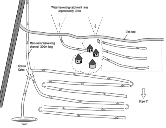
तारकोल की सडक़ पर बहते पानी को करीब 300 मीटर लंबी नहर के जरिए लाया गया जो एक पड़ोसी के खेत से कट कर आती है. इसके अलावा भी कुछ पूरक नहर बनाई गईं जो पहाड़ी से बहते पानी को एकत्रित करतीं. अनुमानित भंडारण क्षेत्र करीब 10 हेक्टेयर है। इससे करीब 5 हेक्टेयर क्षेत्र में सिंचाई होती है. प्रमुख नहर पानी को शुरुआती फान्या चिनि (एक ऐसी नहर जो धरती के सहारे ढलान से बहती है) ढांचे की मदद से निकालती है. जब पानी नहर के आखिरी सिरे पर पहुंचती है तब उसे ऐसे ही एक अन्य ढांचे में मिला दिया जाता है जो पानी को एकदम दूसरी दिशा मेंं ले जाता है. दूसरे शब्द मेंं कहें तो पानी जिगजैग शैली में बहता है. कुछ खास स्थानों पर किसान ने पानी को नियंत्रित करने के लिए गेट लगाया है. इनकी मदद से पानी की दिशा तय की जाती है.
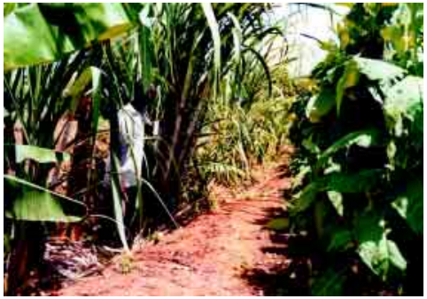
खेतों में पानी लाने वाली व्यवस्था तो आमतौर पर फान्या चिनि होती है लेकिन कई जगह फान्या जु (नहर के ऊपर बनावट) का प्रयोग भी किया जाता है. नहर का आकार प्राय: एक मीटर गहरा, एक से दो मीटर चौड़ा होता है जबकि सतह पर बनी उभरी नहर डेढ़ मीटर ऊंची और 18 मीटर चौड़ी होती है. ये आकार अनुशंसित फान्या जू /फान्या चिनि डिजाइन से कमतर हैं. खेतों की औसत ढलान करीब 3 डिग्री है. ढांचों के बीच अनुमानित लंबाकार अंतराल करीब 0.9 मीटर होता है. इनको घास या केले अथवा गन्ने जैसी सदाबहार फसलों से स्थिर किया जाता है.
Maintenance
Maintenance involves frequent sediment removal to maintain channel capacity, repair of broken channels and embankment sections and replanting grass or dried-up fruit trees along the embankment where necessary.
Costs
An approximate construction input of just over 100 days per hectare is stated for the hand labour involved. That represents the infrastructure of bunds and channels. Other costs (equipment, seedlings etc) are minimal. The annual requirement for maintenance is estimated at 10 person days per hectare. This is less in a dry year, but can be much more due to damage caused by extra runoff during heavy rains. Clearly, while it is a low external-input system, this is a relatively expensive technology, and particularly demanding on labour. Nevertheless because the system is directly linked to increased production, these are costs which can be recovered quickly. The benefits compared with investment costs are recorded to be ‘positive’ in the short term and ‘very positive’ in the longer term.
Field experiences
Improvements
One improvement regarding adoption of the system would be to assist farmers in layout and design. These road runoff harvesting systems can be very effective, but if not well designed or managed may lead to high maintenance requirements and an increased erosion hazard. An idea for improving Musyoka’s system, from the WOCAT data collectors who visited him, is that he could make his channels shallower to allow more water to spillover into his fields, rather than it being lost through deep infiltration. In terms of research, this is one of the systems most in need of validation and full description, as water harvesting is extremely important in the drylands of Kenya. And here is a system that works.
Adoption by other farmers
The farmer has designed systems for two neighbours: indeed the main channel from the road passes through the farm of one of these, with whom he works co-operatively. The total adoption is recorded to be around 40 farmers. They are all now harvesting runoff from tracks or hillsides in this vicinity. However, several of those who have taken up his initiative have not managed to guide the runoff water through the farm as effectively as Musyoka has done.
Manuals, videos and links
- Water from Roads: A handbook for technicians and farmers on harvesting rainwater from roads. Erik Nissen-Petersen for Danish International Development Assistance (Danida), 2006.
- VIDEO: Road Runoff Harvesting
- Roads for Water: roadsforwater.org, video webinar, flash presentation, webinar description
- GRANT AWARD: Optimizing Road Development for Groundwater Recharge and Development - The research project 'Optimizing Road Development for Groundwater Recharge and Retention' investigates how the fast growing road development programs in Sub-Saharan Africa can become 'inclusive' by securing, and where possible improving, the groundwater sources of the poor. Roads have a major but little researched impact on hydrology and local groundwater availability. The aim of the project is to optimize the planning and design of roads in rural areas for the recharge and retention of groundwater, thus contributing to secure and equitable use of shallow groundwater. This should contribute to better water buffering in view of climate variability (and changes therein) and lead to poverty reduction and socio-economic development (groundwater is important to agricultural production/irrigation as well as for drinking water supply).
Acknowledgements
- Kithinji Mutunga and Will Critchley, FARMERS’ INITIATIVES IN LAND HUSBANDRY Promising technologies for the drier areas of East Africa. UNDP – Office to Combat Desertification and Drought (UNSO/ESDG/BDP) and Sida’s Regional Land Management Unit, 2001.
- Water Storage. Infonet-Biovision.org.


