Difference between revisions of "Geospatial Planning"
(→Field experiences) |
(→Manuals, videos and links) |
||
| (5 intermediate revisions by the same user not shown) | |||
| Line 1: | Line 1: | ||
| − | [[Image:Uganda GIS map.jpg|thumb|right|200px|Uganda: Proportion on Households with Improved Sanitation Facilities, 2002. Map: [http://www.wri.org/ | + | [[Image:Uganda GIS map.jpg|thumb|right|200px|Uganda: Proportion on Households with Improved Sanitation Facilities, 2002. Map: [http://www.wri.org/resources/maps/uganda-proportion-households-improved-sanitation-facilities-2002 World Resources Institute]]] |
[[File:flood GIS map.png|thumb|right|200px|Flood water identification in Gambia. Map: [http://belfercenter.ksg.harvard.edu/files/uploads/Geospatial-Science-and-Technology-for-Sustainable-Dev-in-Africa_Ottichilo_Khamala.pdf Kenya National Assembly]]] | [[File:flood GIS map.png|thumb|right|200px|Flood water identification in Gambia. Map: [http://belfercenter.ksg.harvard.edu/files/uploads/Geospatial-Science-and-Technology-for-Sustainable-Dev-in-Africa_Ottichilo_Khamala.pdf Kenya National Assembly]]] | ||
| − | + | __NOTOC__ | |
Geographic Information Systems (GIS) maps are valuable tools to help overcome common coordination challenges in water and sanitation projects. Better information means better decisions about how to allocate resources, and a good map can literally put all parties on the same page, opening the door for more efficient, transparent decision-making. | Geographic Information Systems (GIS) maps are valuable tools to help overcome common coordination challenges in water and sanitation projects. Better information means better decisions about how to allocate resources, and a good map can literally put all parties on the same page, opening the door for more efficient, transparent decision-making. | ||
| Line 15: | Line 15: | ||
===Mapping tools=== | ===Mapping tools=== | ||
* [http://www.waterpointmapper.org/ Water Point Mapper] - The Water Point Mapper is a free tool for producing maps showing the status of water supply services. It is aimed at water, sanitation, hygiene practitioners as well as local governments working at the district and sub-district levels in Sub-Saharan Africa. The Mapper has been designed for use in situations where there is no internet connectivity. The Water Point Mapper was developed by WaterAid. | * [http://www.waterpointmapper.org/ Water Point Mapper] - The Water Point Mapper is a free tool for producing maps showing the status of water supply services. It is aimed at water, sanitation, hygiene practitioners as well as local governments working at the district and sub-district levels in Sub-Saharan Africa. The Mapper has been designed for use in situations where there is no internet connectivity. The Water Point Mapper was developed by WaterAid. | ||
| − | * [http:// | + | * [http://akvo.org/products/akvoflow/ Akvo FLOW] - FLOW stands for Field Level Operations Watch. It’s a system to collect, manage, analyze and display geographically-referenced monitoring and evaluation data.It has been under development for several years with significant field implementations already under its belt. To date FLOW has been used mainly to track the condition of water points such as wells and pumps. But it could be used to monitor any kind of local infrastructure. |
===Field experiences=== | ===Field experiences=== | ||
| Line 26: | Line 26: | ||
<!--project blocks here--> | <!--project blocks here--> | ||
|- style="vertical-align: bottom" | |- style="vertical-align: bottom" | ||
| − | |[[Image: project 447.jpg|thumb|center|140px|<font size="2"><center>[http://rsr.akvo.org/project/447/ RSR Project | + | |[[Image: project 447.jpg|thumb|center|140px|<font size="2"><center>[http://rsr.akvo.org/project/447/ RSR Project 447]<br>E-mainstreaming for DWA Mali</center></font>|link=http://rsr.akvo.org/project/447/]] |
| − | |[[Image:project 830.png |thumb|center|140px|<font size="2"><center>[http://rsr.akvo.org/project/830/ RSR Project | + | |[[Image:project 830.png |thumb|center|140px|<font size="2"><center>[http://rsr.akvo.org/project/830/ RSR Project 830]<br>Scanning and Mapping the WASH Situation</center></font>|link=http://rsr.akvo.org/project/830/ ]] |
|} | |} | ||
| + | |||
| + | <br> | ||
===Manuals, videos and links=== | ===Manuals, videos and links=== | ||
| Line 34: | Line 36: | ||
* [http://www.africageospatialforum.org/ Africa Geospatial Forum]. CTICC, Cape Town, South Africa. 2013. | * [http://www.africageospatialforum.org/ Africa Geospatial Forum]. CTICC, Cape Town, South Africa. 2013. | ||
* [http://belfercenter.ksg.harvard.edu/files/uploads/Geospatial-Science-and-Technology-for-Sustainable-Dev-in-Africa_Ottichilo_Khamala.pdf Geospatial Science and Technology for Sustainable Development in Africa:Partnerships and Applications]. Hon. Dr. Wilbur Ottichilo, M.P.Kenya National Assembly and Erick Khamala Remote Sensing Officer, Regional Centre for Mapping of Resources for Development (RCMRD). | * [http://belfercenter.ksg.harvard.edu/files/uploads/Geospatial-Science-and-Technology-for-Sustainable-Dev-in-Africa_Ottichilo_Khamala.pdf Geospatial Science and Technology for Sustainable Development in Africa:Partnerships and Applications]. Hon. Dr. Wilbur Ottichilo, M.P.Kenya National Assembly and Erick Khamala Remote Sensing Officer, Regional Centre for Mapping of Resources for Development (RCMRD). | ||
| − | *[http://www. | + | *[http://www.glcn.org/index_en.jsp FAO Africover Project]. Contribution to Africa’s SDI Development. John S. Latham, SDRN, FAO. |
* [http://www.un.org/waterforlifedecade/green_economy_2011/pdf/session_5_technology_cases_burkinafaso.pdf Improvement of water supply through a GIS-based monitoring and control system for water loss reduction]. UN Water. Ouagadougou, Burkina Faso. | * [http://www.un.org/waterforlifedecade/green_economy_2011/pdf/session_5_technology_cases_burkinafaso.pdf Improvement of water supply through a GIS-based monitoring and control system for water loss reduction]. UN Water. Ouagadougou, Burkina Faso. | ||
* [http://www.unep.org/pdf/RWH_in_Africa-final.pdf Potential for Rainwater Harvesting in Africa: A GIS Overview]. RELMA in ICRAF & UNEP, October 2005. | * [http://www.unep.org/pdf/RWH_in_Africa-final.pdf Potential for Rainwater Harvesting in Africa: A GIS Overview]. RELMA in ICRAF & UNEP, October 2005. | ||
| − | * [ | + | * [https://www.gislounge.com/five-ways-use-gis-strengthen-nonprofit-fundraising/ The Fantastic Five GIS Tools for Fundraising]. Steve Spiker, Director of Research & Technology, Urban Strategies Council. |
===Acknowledgements=== | ===Acknowledgements=== | ||
* [http://www.wri.org/stories/2009/10/maps-guide-water-and-sanitation-planning-africa Maps Guide Water and Sanitation Planning in Africa]. Norbert Henninger and Florence Landsberg on October 8, 2009. | * [http://www.wri.org/stories/2009/10/maps-guide-water-and-sanitation-planning-africa Maps Guide Water and Sanitation Planning in Africa]. Norbert Henninger and Florence Landsberg on October 8, 2009. | ||
Latest revision as of 03:18, 28 May 2016
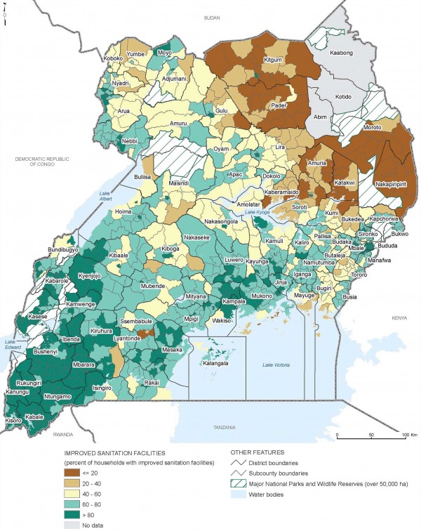
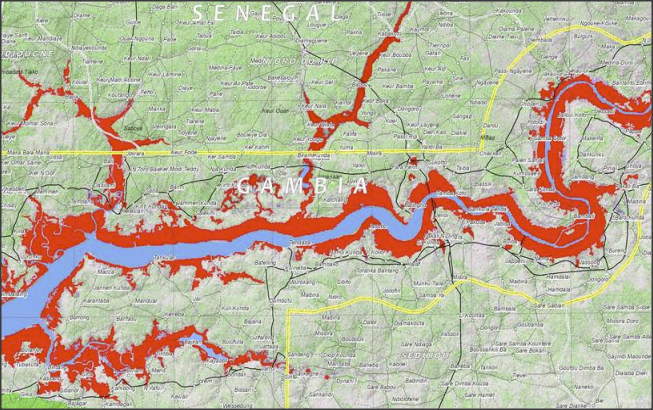
Geographic Information Systems (GIS) maps are valuable tools to help overcome common coordination challenges in water and sanitation projects. Better information means better decisions about how to allocate resources, and a good map can literally put all parties on the same page, opening the door for more efficient, transparent decision-making.
For instance, an examination of the spatial relationships between poverty, safe drinking water, improved sanitation, and better hygiene behavior can provide new information to help craft more effective—and more evidence-based—investments and poverty reduction efforts. This kind of spatial information can also empower the public to query government priorities, advocate for alternative interventions, and demand better decision-making.
| The SamSamWater maps and GIS library
SamSamWater makes information on water and sanitation easy to find and accessible for all. This page contains a database with practical information, data and (GIS)maps. |
Mapping tools
- Water Point Mapper - The Water Point Mapper is a free tool for producing maps showing the status of water supply services. It is aimed at water, sanitation, hygiene practitioners as well as local governments working at the district and sub-district levels in Sub-Saharan Africa. The Mapper has been designed for use in situations where there is no internet connectivity. The Water Point Mapper was developed by WaterAid.
- Akvo FLOW - FLOW stands for Field Level Operations Watch. It’s a system to collect, manage, analyze and display geographically-referenced monitoring and evaluation data.It has been under development for several years with significant field implementations already under its belt. To date FLOW has been used mainly to track the condition of water points such as wells and pumps. But it could be used to monitor any kind of local infrastructure.
Field experiences
 E-mainstreaming for DWA Mali |
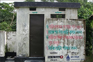 Scanning and Mapping the WASH Situation |
Manuals, videos and links
- A Geospatial Approach to Assessing Water Stress in Africa. World Resources Institute.
- Africa Geospatial Forum. CTICC, Cape Town, South Africa. 2013.
- Geospatial Science and Technology for Sustainable Development in Africa:Partnerships and Applications. Hon. Dr. Wilbur Ottichilo, M.P.Kenya National Assembly and Erick Khamala Remote Sensing Officer, Regional Centre for Mapping of Resources for Development (RCMRD).
- FAO Africover Project. Contribution to Africa’s SDI Development. John S. Latham, SDRN, FAO.
- Improvement of water supply through a GIS-based monitoring and control system for water loss reduction. UN Water. Ouagadougou, Burkina Faso.
- Potential for Rainwater Harvesting in Africa: A GIS Overview. RELMA in ICRAF & UNEP, October 2005.
- The Fantastic Five GIS Tools for Fundraising. Steve Spiker, Director of Research & Technology, Urban Strategies Council.
Acknowledgements
- Maps Guide Water and Sanitation Planning in Africa. Norbert Henninger and Florence Landsberg on October 8, 2009.
