Difference between revisions of "वाटर पोर्टल / वर्षाजल संचयन / रवांबू यूगांडा पहाड़ियां"
| Line 2: | Line 2: | ||
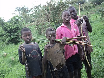
[[Image:Rwambu project.jpg|thumb|right|200px|A wetland management and water harvesting project of the Rwambu catchment in Uganda. Photo: [http://www.akvo.org/rsr/project/439/ Akvo.org]]] | [[Image:Rwambu project.jpg|thumb|right|200px|A wetland management and water harvesting project of the Rwambu catchment in Uganda. Photo: [http://www.akvo.org/rsr/project/439/ Akvo.org]]] | ||
| − | <font color=#555555>''' | + | <font color=#555555>'''परियोजना अवधि: '''क्रियान्वयन के लिए अक्टूबर 2012 से दिसंबर 2013 तक। दस्तावेजी और शिक्षण के लिए और समय दरकार.</font> |
===प्राथमिक चुनौतियाँ=== | ===प्राथमिक चुनौतियाँ=== | ||
Revision as of 18:51, 1 December 2015
| |
|
|
|
|
|
|
|
|

परियोजना अवधि: क्रियान्वयन के लिए अक्टूबर 2012 से दिसंबर 2013 तक। दस्तावेजी और शिक्षण के लिए और समय दरकार.
Contents
प्राथमिक चुनौतियाँ
मौजूदा स्थिति
प्रायोगिक इलाके में कई पहाड़ी इलाके और अलग-अलग तरह की मृदा वाले इलाके हैं. इन सभी में कृषि संबंधी गतिविधियों में इजाफा देखने को मिला लेकिन जल स्तर में गिरावट आई. मौजूदा कृषि व्यवहार स्थायी नहीं नजर आ रहा है क्योंकि उपज पैदा करने के लिए तलाशी गई नई जगहें बहुत ऊंची और कटाव के जोखिम वाली हैं. हालांकि यह प्रचुर वर्षा वाला क्षेत्र है और यहां 700 से 1000 मिमी तक बारिश दर्ज की जाती है लेकिन फिर भी बीते वर्षों के दौरान यहां जल स्तर मेंं जमकर गिरावट आई है. झरने और उथले कुंए आदि सूख गए हैं. शायद ऐसा तेज कृषि गतिविधियों की वजह से हुआ हो. स्थानीय लोगों के मुताबिक हाल के वर्षों में बारिश अनियमित हुई है. उस पर जलवायु परिवर्तन का असर साफ नजर आ रहा है.
सामाजिक आर्थिक और सांस्कृतिक परिस्थितियां
वर्ष 2011 में हुए व्यवहार्यता अध्ययन से मिले संकेत के मुताबिक इस क्षेत्र के 75 फीसदी लोग प्रति दिन एक यूरो से कम में गुजारा करते हैं. केला इस इलाके का प्रमुख भोजन है जो यहां प्रचुर मात्रा में होता है लेकिन इसे बैक्टीरिया का जोखिम रहता है. नकदी फसलों मसलन कॉफी, मूंगफली और पत्ता गोभी का चलन बढ़ रहा है. दक्षिण में रवांडा की सीमा के निकट से लोगों का प्रवासन बहुत बढ़ रहा है. इससे तमाम सांस्कृतिक समूह एक साथ आ रहे हैं. इस क्षेत्र में इस्लामिक और ईसाई आस्थाओं को मानने वाले आए हैं.
Pilot landscape
The landscape is grass-covered and hilly (highest approx. 1550 meters above sea-level) with valleys of 1250 meters above sea-level, and other hills are with rocky surfaces. The slopes of the hills consist of loamy and clay soils reaching down as thick as 4 meters. In the valleys, a wetland or marshland follows the Rwambu river.
Pilot purpose
The uphill areas require protection measures for erosion and runoff and would benefit from the increase in recharge produced by these protection measures. Due to the variety of slopes and soil types, 5 different technologies are going to be implemented.
Location and partners

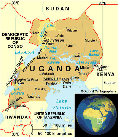
- Location: The Rwambu area is in the West of Uganda on the boundary of the Ibanda and Kamwenge districts, Latitude: 0° 1'33.03" North of the Equator. Longitude: 30°24'55.54" East of Greenwich Meridian.
- Main partner: Joint Effort to Save the Environment (JESE)
- Role and responsibility of main partner: JESE proposed the intervention area, worked with RAIN and Wetlands International and URWA on the program development and is the sole implementer of the project.
- Other partners: Wetlands International and Uganda Rain Water Association (URWA)
- Role and responsibilities of other partners: Technical advice, program advice, capacity building.
Description
- To compensate people who had to abandon cultivation in the wetland area.
- Themes: 3R, food security, reforestation and soil stability
Strategy
The strategy will be to divide the hill into different sections. On the top of the hill, that is now only used for grazing, we will plant trees. It is expected that the type of tree Grevillea Robusta will grow productively on the top of these hills without disturbing its agricultural use. The Grevillea is planted to stabilize the soil and catch more rainwater and allow it to infiltrate into the hill slope without diminishing the opportunity for grazing cattle.
Specific actions taken in 2012 and 2013: Plant 5000 Grevillea tree seedlings in a micro basin style, planting a distance of 5 meters. Further downhill on these slopes people have started tilling the soil in a way that will not be sustainable in the long term. Agro forestry is promoted on the steeper slopes as well as soil protection measures like grass bunds, grass strips, hillside terraces and staggered trenches. The short-term effects will be retention of runoff water and soil sediments.
For the same reason, indigenous tree species (seed farmer managed) that might be used for firewood will be promoted. Uphill improvement in the banana, groundnut and coffee plantations contribute to boundary marking, so instead of trenches we promote vetiva grass or elephant grass. Additionally, terracing (Fanya juus) is already being implemented and will continue into 2013.
Objectives
- Stabilize agricultural lands on the slopes.
- Recharge the groundwater table on these slopes.
Activities (2013)
- Fill the entire hill with trees e.g. 2000 on the Ibanda side.
- Promote Agroforestry on the steeper slopes (grass bunds, grass strips, hillside terraces).
- Promotion / trial of indigenous tree species that are seed-farmer managed that might be coppiced.
- Stone bunds: increase the linear length to 4000m and effective height using vetivar grass.
- Establish runoff systems, i.e. staggering principle.
- Introduce alternatives for boundary marking (instead of trenches), using vetivar or elephant grass.
- Increase linear length of Fanya juus terraces to 3000m.
Planning and process
Year 2012 saw the advent of this program as Fanya Juu terracing was done in the banana plantations. Some 500 gravellia trees were planted and stone bunds were constructed. We are now developing a plan for research and documentation via satellite imagery together with MetaMeta, and JESE will do the implementation.
SWOT analysis
Here is a SWOT analysis (Strengths, Weaknesses, Opportunities, and Threats) of the project:
Strengths:
|
Weaknesses:
|
Opportunities:
|
Threats:
|
| Current situation | Expected results | Actual results | |
|---|---|---|---|
| Water supply | Dried up springs and shallow wells, people are now depending on open source of water such as the wetland. | Several springs revived, improvement of soil and water retention for 150000 M2 agricultural land. | |
| MUS | Drinking water is a problem but this is addressed in another project, the in situ measures will however restore the groundwater potential. | Better soil moisture for agricultural land | |
| 3R | Recharge | Recharge of water table uphill and slower drainage into wetland | |
| Business development | Coffee plantations, groundnut plantations, increase of arable land | Environmental sustainability of these plantations |
Outputs
Technical
- Type(s) of water harvesting: in situ
- Type(s) of storage system(s): terraces (Fanya Juu, Fanya Chini), woodlots, stone and grass bunds, staggered trenching
- Number of systems: 6 different systems
- Total volume (m3): difficult to establish
