Difference between revisions of "Creating a Site Plan Sketch"
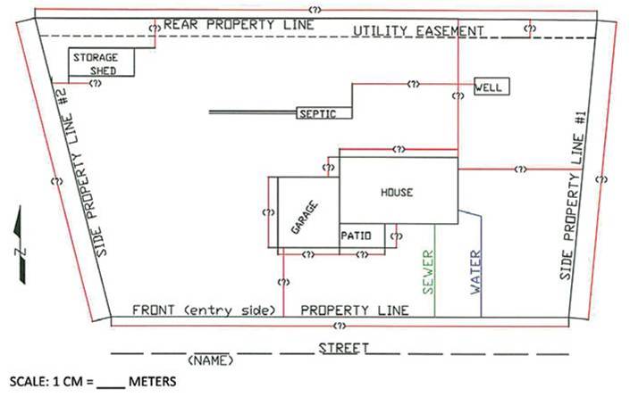
(Created page with "File:Site evaluation 01.jpg|thumb|left|500px|Sample site plan sketch. Notice the main feature property boundaries are shown, plus the nearest street septic tank and off-site...") |
(No difference)
|
Revision as of 20:01, 21 September 2016
How to Make a Site Plan Sketch
On a sheet of paper, sketch the features of the site. Make sure to record the locations of the following:
- Buildings and structures
- Property lines
- Neighboring building and land use (residential, commercial, other)
- Location of water service connections (wells or water district service)
- Septic tanks, sewer lines and discharge points
- Driveway and nearest road
- Slope, cut banks, streams or rivers, floodplains
Hint- Take your time. Try and draw the site plan to scale to the extent possible. Interview the homeowner or resident to determine where the property lines are. Ask if other buildings or homes are connected to the septic tank.
Hint - Laundry washing discharges or kitchen wastes often do not drain to the septic tank. Talk to the owner and determine if this is the case. If so, sketch the location and plot the discharge drainage.
Hint - In many situations, there is no septic tank at all. Residents may use a pit latrine or practice open defecation. The site evaluation must identify these conditions if they exist.
Hint - While making the site plan sketch, look for open spaces that might be used for future sanitation improvements, such as the installation of a new or upgraded septic tank, installation of an improved pit toilet (if no toilets exist), or areas where greywater may be used for on-site irrigation.
Site Plan Checklist
The following should be shown on the site plan sketch:
- North arrow
- Nearest street or road
- Property lines
- Parking area
- All buildings and paved areas
- Location of well, water line
- Location of existing septic tank, pit toilet, other sanitary structures
- Greywater discharge point
- Sewer line from building to septic tank, septic tank to sewer
- Topography: provide arrows that indicate the slope
Questions to consider as you make the site plan sketch:
Is this property in a floodplain?
• Yes. If so, how often does it flood, and how high does the floodwater get?
Are buildings from neighboring properties connected to the septic tank?
• Yes. If so, be sure to draw them along with the sewer lines
• No
Are roof gutters and surface drainage directed away from the septic tank?
• Yes
• No
Is there any land on the property available for a new septic tank, pit toilet, and/or on-site irrigation?
• Yes. If so, identify it on the site plan
• No
Where does the wastewater go after it leaves the building/septic tank?
• All underground – it leaches from the septic tank
• Effluent or sewage flows through a closed pipe or channel to off-site drainage
• Effluent or sewage flows through an open channel to off-site drainage

